

Lake levels rise and fall seasonally because of one core principle hydrologists call the water budget: the net balance between water flowing in (precipitation, snowmelt, runoff, and groundwater) and water flowing out (evaporation, controlled releases, and river outflow). For renters on lakes near Spokane Valley, Liberty Lake, and Coeur d'Alene, that balance translates directly into launch depth, prop clearance, and safe navigation. Expect higher water in spring and early summer, lower water by late summer and fall. The International Joint Commission confirms that water levels operate at three scales: long-term trends, seasonal cycles measured in months, and short-term shifts that can happen in hours due to wind.
The water budget predicts the season. Spring snowmelt and rain tip the balance toward inflow; late-summer evaporation and withdrawals tip it toward outflow. On large lakes like the Great Lakes, that seasonal swing typically runs 1–2 feet between the high and low points of the year. Smaller inland lakes can swing more sharply.
Check a real-time gauge before you launch, every time.
Table of Contents
- Why do lake levels change seasonally? The water budget explained
- What months should you expect higher or lower water on inland Northwest lakes?
- Short-term hazards boaters need to watch before launching
- How dams and water managers change what you see on the water
- What to check before you rent or launch: a boater's checklist
- Local notes for Spokane Valley, Liberty Lake, and Coeur d'Alene
- How groundwater quietly shapes lake levels
- Key Takeaways
- A local operator's perspective on reading the lake
- Plan your rental around current lake conditions with Goldenwatersports
- Where to check authoritative lake-level and management information
Why do lake levels change seasonally? The water budget explained
The water budget is simply a ledger: add up every drop entering the lake, subtract every drop leaving, and the difference tells you whether the lake rises or falls.
Inflows that raise levels:
- Snowmelt and spring rain running off the surrounding watershed
- Direct precipitation falling on the lake surface
- Groundwater seeping in through the lakebed and banks
- Stream and river inflow from the drainage basin
Outflows that lower levels:
- Evaporation from the lake surface
- Outflow through rivers, spillways, or dam releases
- Consumptive withdrawals (irrigation, municipal supply)
Evaporation deserves special attention. It peaks when cold, dry air moves over relatively warm water, which is exactly what happens in fall and early winter. The Ohio Department of Natural Resources notes this dynamic as a key driver of late-season level drops. You can have a string of pleasant October days and still watch the lake fall, because the air-water temperature gap is doing the work invisibly.
MSU Extension frames it plainly: the water budget concept is the single most useful tool for predicting whether a lake will be high or low in any given season.
GLISA research also shows that summertime evaporation rates have more than doubled for some metrics since the 1980s, meaning late-season drops can arrive earlier and run deeper than they did a generation ago.

What months should you expect higher or lower water on inland Northwest lakes?
Regional timing shifts with snowpack and rainfall, but the pattern below holds in most years for lakes near Spokane Valley, Liberty Lake, and Coeur d'Alene.
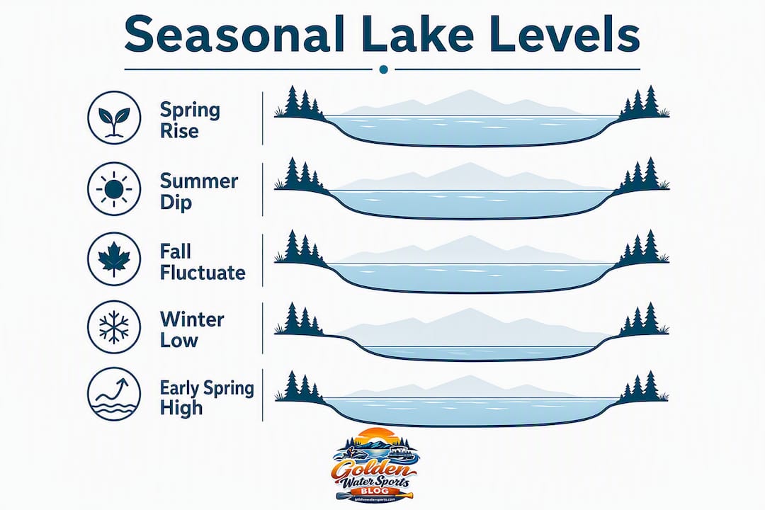
| Season | Typical Months | What's Happening | Level Trend |
|---|---|---|---|
| Late winter low | January–March | Minimal inflow, cold temps limit evaporation | Near annual low |
| Spring rise | March–May | Snowmelt and rain runoff surge inflows | Rising fast |
| Early-summer peak | May–June | Inflows still strong, evaporation not yet dominant | Near annual high |
| Late-summer decline | July–September | Evaporation accelerates, withdrawals increase | Falling steadily |
| Fall drop | October–November | Cold air over warm water drives rapid evaporation | Sharpest drop |
Wet years push every phase higher and later; drought years compress the spring rise and accelerate the fall decline. Inter-annual climate variability means the table above is a typical pattern, not a guarantee. A low-snowpack winter followed by a dry spring can put the lake at late-summer levels by early June.
Short-term hazards boaters need to watch before launching
Seasonal averages tell you the general story. Wind tells you what's happening right now.
Strong, sustained winds push water toward one end of a lake, a phenomenon called a surge. When the wind dies, the water sloshes back and oscillates, sometimes for hours. That oscillation is a seiche. On Lake Ontario, wind surges have raised local levels by as much as 1.5 feet within hours. Coeur d'Alene, with its long north-south fetch, is particularly susceptible to this effect during sustained southwest winds.
Hazards renters should watch for:
- Suddenly shallow launch ramps after a surge drains one end of the lake
- Strong currents near inlets and outlets when water is actively moving
- Confused chop near coves and marinas where reflected waves meet incoming ones
- Submerged rocks and stumps exposed when levels drop below seasonal norms
Short-term weather events can make a lake look completely different within hours, and seasonal averages offer no warning. Check wind history and local gauge readings the morning of your rental, not the night before.
Pro Tip: Before launching, pull up the NOAA weather forecast for your specific lake and look at sustained wind speed and direction over the prior 12 hours. A recent 20+ mph wind from a consistent direction is a signal to ask your rental operator about current ramp conditions before you trailer down.
How dams and water managers change what you see on the water
Not every lake behaves naturally. Managed reservoirs follow a schedule set by dam operators, water utilities, and sometimes state regulators, and that schedule can override the seasonal pattern entirely.
| Feature | Natural Lake | Managed Reservoir |
|---|---|---|
| Level control | None — follows water budget | Dam gates and releases |
| Spring rise | Driven by snowmelt/runoff | May be held low for flood storage |
| Summer level | Peaks with inflow | Held high for recreation or supply |
| Fall drawdown | Gradual evaporation-driven | Can be rapid and deliberate |
| Predictability | Follows climate patterns | Follows operator schedule |
A deliberate drawdown is usually functioning water management, not a problem. Operators lower reservoirs to create storage capacity before spring runoff, meet downstream flow requirements, or respond to drought conditions. The drop is real, but it is planned.
What renters should do:
- Check the dam operator's website or posted notices before launching near outlets
- Ask your rental operator whether your target lake is managed and whether any scheduled releases are pending
- Treat a sudden mid-summer drop on a reservoir as a management decision, not an anomaly
What to check before you rent or launch: a boater's checklist
Turn the science into a five-minute pre-launch routine.
- Check the current gauge reading. NOAA's Lake Level Viewer and USGS stream gauges cover many regional lakes. Know whether you're above or below the seasonal average.
- Review recent wind history. Look at the prior 12–24 hours. A sustained directional wind means one end of the lake may be higher or lower than normal.
- Confirm launch ramp depth. Call the ramp or ask Goldenwatersports. A ramp that worked in June may have 18 inches less water in September.
- Identify channel markers and known obstructions. Low water exposes hazards that are invisible at normal levels. Ask specifically about shallow zones near your planned route.
- Verify minimum depth for your activity. Water skiing requires more clearance than a pontoon cruise. Check the safe depth requirements for your planned activity before you book.
- Confirm safety gear is aboard. Life jackets, a throw rope, and a whistle are non-negotiable regardless of conditions.
Pro Tip: When water is low and you're anchoring near shore, approach at a slow idle and use a stern anchor to hold your angle rather than dropping the bow anchor and drifting forward into shallower water. More on correct anchoring technique can save you a prop.
Local notes for Spokane Valley, Liberty Lake, and Coeur d'Alene
These three areas each have their own quirks when water levels shift.
- Coeur d'Alene: The lake's long fetch amplifies wind-driven surges. Southwest winds are the most common culprit. The city marina and Tubbs Hill launch areas can see noticeably different depths within the same afternoon during a sustained blow. Check the Liberty Lake water activities checklist for comparable safety reminders that apply across the region.
- Liberty Lake: Smaller basin, faster response. A single heavy rainstorm can raise Liberty Lake several inches in 24 hours; a dry August week can drop it just as fast. The shallow eastern end is the first area to become problematic in low-water years.
- Spokane Valley area lakes: Levels here are more directly tied to regional snowpack. A low-snowpack winter, like several the inland Northwest has seen recently, means the spring rise arrives later and peaks lower.
Goldenwatersports staff monitor gauge readings throughout the season and adjust launch ramp recommendations accordingly. When levels are low, the team typically steers renters toward deeper-launch locations and recommends pontoon boats over higher-draft ski boats for shallow-water days.
How groundwater quietly shapes lake levels
Groundwater is the hidden variable most renters never think about. Lakes don't just sit on top of the ground; they interact with the aquifer beneath and around them through a process called groundwater exchange.
When the water table is high (typically after a wet winter or spring), groundwater seeps into the lake through the lakebed and banks, adding volume even on days with no rain. When the water table drops in late summer, the flow can reverse: the lake loses water into the surrounding aquifer, accelerating the seasonal decline beyond what evaporation alone would cause.
For inland Northwest lakes sitting on permeable soils and fractured basalt, this exchange is significant. Liberty Lake, in particular, has documented groundwater connections that make its level sensitive to regional aquifer conditions, not just local precipitation. A dry year that depletes the aquifer can pull lake levels down through groundwater outflow even after surface runoff has stopped. The International Joint Commission identifies groundwater and stream-flow transport as core components of the hydrologic system governing lake levels.
Key Takeaways
Seasonal lake-level change is driven by the water budget: spring snowmelt and runoff raise levels, while late-summer evaporation, withdrawals, and groundwater outflow pull them back down.
| Point | Details |
|---|---|
| Water budget is the core concept | Inflows (snowmelt, rain, groundwater) minus outflows (evaporation, releases) determine whether a lake rises or falls. |
| Spring peak, fall drop | Inland Northwest lakes typically peak in May–June and reach their lowest point by October–November. |
| Wind can shift levels in hours | Surges and seiches can raise or lower local levels by over a foot; check wind history before launching. |
| Managed reservoirs follow a schedule | Deliberate drawdowns are planned; check dam operator notices before launching near outlets. |
| Goldenwatersports adjusts by season | Staff monitor gauges and recommend craft and ramps suited to current water levels for your outing. |
A local operator's perspective on reading the lake
Water levels are something Goldenwatersports pays attention to every single day of the rental season. Staff check gauge readings each morning, compare them to the prior week's trend, and make real-time calls on which launch ramps to recommend and which craft fit the conditions. When Coeur d'Alene is running low in late August, a pontoon boat with its shallower draft often makes more sense than a ski boat for guests who want to explore the southern bays. Every renter gets a pre-launch briefing that covers current conditions, life jacket fitting, and any known shallow zones on their planned route. That local knowledge, built from seasons on these specific lakes, is something no gauge reading alone can replace.
Plan your rental around current lake conditions with Goldenwatersports
Knowing why lake levels shift is useful. Having a local team that tracks those shifts daily and builds your rental plan around them is better.
Goldenwatersports serves Spokane Valley, Liberty Lake, and Coeur d'Alene with Yamaha WaveRunners, ski boats, pontoon boats, paddleboards, and water toys, all paired with safety gear and flexible hourly or multi-day rental periods. Pickup and towing options mean you're not stuck if conditions change. The team's seasonal gauge monitoring means you get a launch ramp recommendation that actually works on the day you show up, not one based on last month's water level. Check current rental availability and pricing and book the craft that fits your lake, your group, and the conditions on the water right now.
Where to check authoritative lake-level and management information
- NOAA Lake Level Viewer: Interactive tool for historical and current water levels; useful for understanding seasonal patterns and visualizing level changes.
- International Joint Commission: Authoritative source on natural and managed influences on lake levels; explains the three temporal scales of level change.
- GLISA (Great Lakes Integrated Sciences and Assessments): Climate-informed lake-level analysis; useful for understanding inter-annual variability and long-term evaporation trends.
- MSU Extension: Plain-language explanation of the water budget and seasonal cycle; good starting point for renters new to the concept.
- USGS StreamStats and WaterWatch: Real-time stream and lake gauge data for Pacific Northwest watersheds; search by location for the gauge nearest your target lake.
- Idaho Department of Environmental Quality / Washington Department of Ecology: State-level water quality and level monitoring notices; check for seasonal advisories and management updates on regional lakes.
- Local dam operator websites: For managed impoundments, operator pages post scheduled release notices and current pool elevations; search by dam name plus "operations" or "pool level."